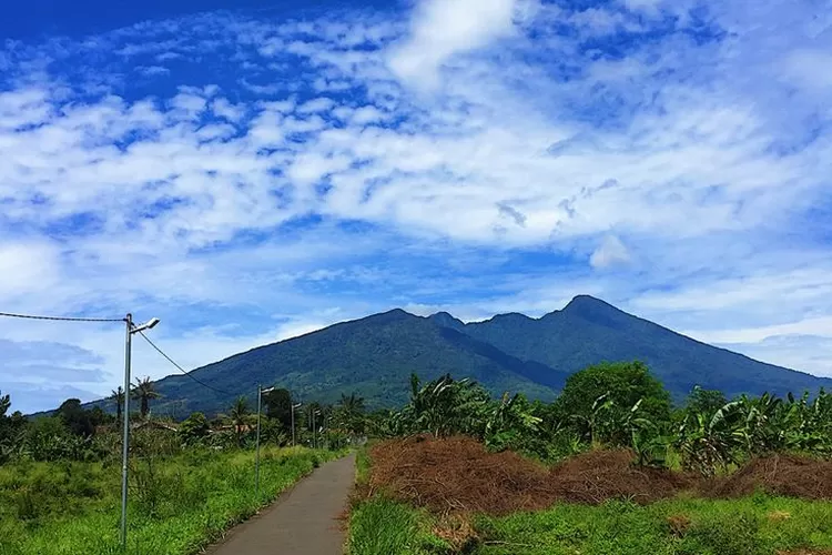
Mount Salak is a majestic peak located in West Java, Indonesia. This mountain is known for its breathtaking views and challenging hiking trails. Many adventurers flock to Mount Salak to test their skills and enjoy the beauty of nature. With its lush forests and diverse wildlife, Mount Salak offers a unique experience for those who seek adventure and tranquility in equal measure.
Mount Salak is a popular destination for both locals and tourists alike. Its towering presence and mystical allure make it a must-visit for anyone exploring the region. Whether you are an experienced hiker or a casual nature lover, Mount Salak has something to offer for everyone. From its cool mountain air to its stunning vistas, this mountain never fails to impress those who venture to its slopes.
Mount Salak holds a special place in the hearts of many Indonesians, as it is not just a mountain but a symbol of the country's natural beauty and rich heritage. Its name evokes a sense of pride and reverence among those who call Indonesia home. For centuries, Mount Salak has stood as a testament to the enduring spirit of the Indonesian people and the timeless allure of the natural world. Visit Mount Salak and discover the magic and wonder that this mountain has to offer.
Pasawahan, District. Cicurug, Sukabumi Regency, West Java 43359

The Kutajaya or Cimelati route is the shortest and fastest climbing route to the peak of Mount Salak, but along the way, it can be difficult to find a water source, so clean water should be prepared from the bottom. To reach Kutajaya from Bogor, we can take a car towards Sukabumi and get off at Cicurug or Cimelati.
Cicurug is a sub-district town located in the Sukabumi regency area, and all climbing equipment should be prepared here. From the Cicurug market, which also serves as a terminal, we can rent a car to Kutajaya for around Rp.70,000, or take a motorcycle taxi for around Rp.15,000. Public transportation is only available in the morning, and even then, in very limited numbers.
The journey begins from the village of Kutajaya, passing through the fields and agricultural gardens of the residents. Due to the many branches along the way, it is advisable to travel during the day and try to always follow the mountain ridge.
Finding the path to the waterfall may be a bit challenging. While there are clear signs at each checkpoint, the signs pointing towards the peak are scarce. To aid in navigation, there are some clues available in the form of raffia ropes. Along the trail, there are no spacious and flat areas to set up a tent. However, at some checkpoints, there are spots large enough to pitch 1-2 small-sized tents. This trail is rarely traversed by hikers, so sometimes it may be overgrown with grass and foliage.
After passing through the villagers' farmland, the trail begins to cut through a dense forest that is not overly humid. Further along, you will encounter a junction leading to Kutajaya, the waterfall, and the peak. Walking towards the peak for a few hundred meters will bring you to checkpoint 3. The trail continues to ascend through the thick forests. At checkpoint 4, you will come across another fork in the path. Here, you will see a water pipe; do not follow the water pipe either upwards (left) or downwards (right). Most importantly, do not damage the water pipe to obtain drinking water.
It is important to follow the given instructions carefully to navigate the trail safely and responsibly. By paying attention to the clues provided, such as the raffia ropes and the checkpoints, hikers can successfully reach the waterfall and the peak. Respecting the environment and the resources along the trail, like the water pipe, is crucial to preserve the natural beauty of the area for future visitors. Despite the challenges posed by the trail's infrequent use and overgrowth, following the guidelines will ensure an enjoyable and rewarding hiking experience.
After passing through post 4, the trail becomes quite clear and there are not many branches anymore. By walking for about 1 hour, you will reach post 5. The trail becomes steeper as it crosses dense forests, and sometimes we have to cross tree roots. Along the Kutajaya trail, the view is monotonous with only forests, but sometimes we will see various types of birds, hear monkey sounds, and often groups of monkeys crossing the trail.
To reach post 6, it takes about 1 hour of travel time. At post 6, there is a flat land spacious enough to set up 1 tent. It still takes about 1 more hour of travel time to reach the peak of Mount Salak 1. Still in the atmosphere of the increasingly dense forest and accompanied by stronger winds, the path sometimes consists of large rocks when approaching the peak. Arriving right next to the tomb of Mbah Gunung Salak, we will reach the peak of Mount Salak 1 with an altitude of 2,211 meters above sea level.
The journey to the peak of Mount Salak 1 offers a challenging yet rewarding experience for those who are willing to endure the steep trails and changing landscapes. The encounter with wildlife and the sounds of nature along the way add to the adventure of the trek. The final destination at the summit provides a sense of accomplishment and a breathtaking view that makes the entire journey worthwhile.
Kp Panagan, Cidahu Village, Cidahu District, Sukabumi Regency, West Java 43359

Mount Salak via Cidahu, Sukabumi. To hike through the Cidahu route, hikers have an estimated travel time of 7-8 hours. The journey towards the peak of Salak begins from the Registration Post in Cidahu (PTNW Resort Kawah Ratu) Halimun Salak National Park (TNGHS).
From the Registration Post to the entrance gate of the climb takes approximately 30 minutes of travel, then from the entrance gate to the Bahjuri intersection can be reached in 1 hour.
Next, from Bahjuri Intersection to HM 24 camp area takes 3 hours of travel, then from the Camp Area to the Shadow Peak takes 2.5 hours.
The journey from Puncak Bayangan to Puncak Salak, which stands at an altitude of 2,211 meters above sea level, takes approximately 1.5 hours. On the other hand, if you wish to reach Kawah Ratu from Simpang Bahjuri, it can be reached in about 1 hour.
It is important to note that the last water source to the summit is only available at Simpang Bahjuri. Additionally, ensure that you are in good health when embarking on the hike to Mount Salak, and it is mandatory to register and bring a photocopy of your identification document such as ID card/driver's license/student card.
Don't forget to bring a health certificate and bring back your trash. Remember not to leave any litter behind as the mountain is not a garbage dump.
Jl. Mrs. Bunder, Mr. Picung, District Pamijahan, Bogor Regency, West Java 16810

The hiking trail of Mount Salak via Pasir Reungit is the longest route that needs to be traversed. In order to reach the Peak of Salak I, hikers must walk around Kawah Ratu. The Pasir Reungit trail offers a picturesque view that is no less beautiful than the Cidahu trail. Along this trail, there are two small craters known as Kawah Monyet and Kawah Anjing. During the rainy season, these two craters transform into natural water sources that can be used by hikers.
Interested in hiking Mount Salak via the Pasir Reungit Trail? First, take the KRL or bus towards Bogor. Upon arriving in Bogor, take public transportation on the Bebulak route and get off at the Bebulak terminal. From the Bebulak terminal, continue the journey using rural transportation towards Leuwiliang, then get off at the Cibatok intersection.
Once you have reached the Cibatok intersection, you can start your trek towards Mount Salak via the Pasir Reungit Trail. Be prepared for a long and challenging hike, but the stunning views and natural beauty along the way will surely make it a rewarding experience. Remember to respect the environment and follow all safety guidelines to ensure a safe and enjoyable trekking adventure.
How much do you pay to enter Mount Salak?
Location and Entrance Ticket to Mount Halimun Salak National Park
To enter the Gunung Halimun Salak National Park area, you have to pay IDR 5 thousand/person per day for Indonesian citizens and IDR 150 thousand/person per day for foreigners.
CLIMBING PROCEDURE
Quota
The number of climbers climbing Mount Salak is determined by a quota system, namely 200 people/day including Cidahu Gate, Cimalati and Pasir Reungit Gate.
Climbing Registration
Registration/reservations for climbing Mount Salak are carried out using an online system, with the following conditions:
Booking is applied for prospective climbers, both domestic and international, online;
Bookings are made by filling in the form which can be accessed from the BTNGHS website: bookingpendakiantnghs.menlhk.go.id by following the online booking registration flow, namely: Selecting the desired climbing date and route, if the quota is still sufficient then that date and climbing route can be accessed.
Filling in personal data for domestic and foreign tourists includes name, address, place, date of birth, identity card (KTP/SIM/KITAS/Passport), telephone number and email.
Make orders and pay PNBP via transfer of Other Revenue Account Numbers.
After making payment, you will be given a booking code in the form of a QR Code.
Online booking reservations are open 1 (one) month before the climbing date and no later than 1 (one) day before if quota is still available.
Climbing is carried out in groups with a minimum of 4 (four) people and a maximum of 10 (ten) people, chaired by 1 (one) person whose role is responsible for the complete administration and safety of its members.
The QR Code is proof of registration when entering the climbing route.
Climbing registration via online booking cannot be cancelled.
Climbing Implementation
Climbing Mount Salak includes regular (2 days 1 night), traditional, official, religious and Trekking Organizer (TO) climbing with climbing times starting from 08.00 to 16.00 WIB.
Prospective climbers, both domestic tourists and foreign tourists, can register at the entrance to the chosen climbing route by showing proof of the QR Code.
Prospective climbers get information about climbing routes and natural resource potential at the information center.
After receiving service at the information center, prospective climbers will receive a safety talk given by the officer.
After the safety talk, prospective climbers can submit a letter of the results of a health examination that has been carried out by medical personnel at the health center, clinic or practicing doctor. If the health results comply with the provisions, the prospective climber will continue to check the goods/equipment.
Inspection of items by officers according to the luggage list when registering online.
Climbers who carry out special purposes such as research, taking photos for commercial purposes, making videos/films and so on, must arrange SIMAKSI at the TNGHS Hall office;
Climbers who use drone equipment must obtain permission from the TNGHS Center in accordance with the provisions of PP No. 12 of 2014.
A mechanism for incidental closure of the Mount Salak climbing route has been determined by the Head of the TNGHS Center and announced via the website and/or other media. Climbing closures are carried out at any time by the TNGHS Hall if necessary. The climb will be temporarily closed if there is a danger of landslides, storms, hurricanes, search and rescue activities and forest fires to protect climbers from the danger of accidents.
For more details, please read the link below:
Standard Operational Procedures. : SOP for climbing Mount Salak
Climbing Booking Guide: Online Booking Guide for Mount Salak Climbers
Mount Salak has a height of around 2,211 meters above sea level and is an active volcano in Indonesia.
Interesting Facts about Mount Salak
1. Mount Salak is an active volcano
There are several active craters such as Kawah Ratu, Cikuluwung Putri Crater, and Hirup Crater which are part of Kawah Ratu. Since the 1600s, several eruptions have been recorded. The last eruption occurred in 1938, as a phreatic eruption in the Cikuluwung Putri crater.
2. First eruption of Mount Salak
The first eruption of Mount Salak occurred in the 16th century. Several eruptions of Mount Salak were recorded, including successive eruptions in 1668-1699, 1780, 1902-1903 and 1935. The last eruption occurred in 1938, in the form of a phreatic eruption that occurred in the crater. Cikuluwung Putri.
According to PVMBG records, the largest eruption occurred in 1699 which was a very destructive magma eruption but the number of casualties is not yet known.
Morphologically, Mount Salak has many steep and deep ravines. So the entire mountain up to the top is covered in dense forest, it is not easy to see the outline of this mountain.
3. Many climbing routes
One of the interesting facts about Mount Salak is that it has many climbing routes, which include the Ajisaka route, Cidahu route, Cimelati route, you can also go via the Rengit Market route.
The most popular route is through the jackfruit waterfall, Bogor Regency, where you can only reach 2 peaks. Another route is via Cidahu, Sukabumi or Pasir Reungit, close to Mount Bunder, Bogor Regency. This route will take climbers to Peak 1.
4. Prohibition
There is something that climbers who want to visit Mount Salak must not violate, namely the prohibition on picking orchids. Apart from that, you should never ask where the snake fruit is located on Mount Salak.
The origin of the name salak on Mount Salak actually comes from the Sanskrit word "Salaka" which means money, not salak fruit. Therefore Mount Salak means "Silver Mountain".
5. Dangerous for aviation
Mount Salak has quite dense forests and contours that are difficult to recognize. Planes avoid routes over the Mount Salak area because they are dangerous. This place is covered with vast forests and frequent fog can make flying dangerous.
The Sukhoi plane crash occurred on one of the cliffs of Mount Salak in 2012. The Mount Salak area is known in aviation circles as Death Mountain because it is so dangerous.
6. Many Mysteries and Myths
Mount Salak is often said to be the most haunted mountain in West Java and even Indonesia. Stories of several climbers who disappeared and died have appeared many times. It is not uncommon for climbers to experience strange incidents while climbing Mount Salak.
One legend states that there is the center of the magical kingdom of Pajajara at Puncak Manik Mount Salak. Puncak Manik is like a holy place that is cut off from human activity. Apart from that, residents on the slopes of Mount Salak also believe in the existence of supernatural beings. This creature is said to be the reincarnation of a king who has been remembered throughout the ages, Sri Baduga Maharaja Prabu Siliwangi.
This reincarnation of Prabu Siliwangi is said to lead the magical kingdom of Pajajaran on Mount Salak.
Well, that's a series of interesting facts about Mount Salak, which is a favorite tourist destination in West Java but turns out to be haunted and holds many mysteries. Still interested in coming here?